


Beverly 16 Voting District, Platte County, Missouri
About
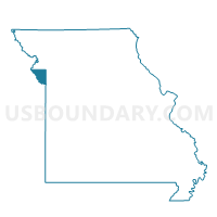
Outline

Summary
| Unique Area Identifier | 609444 |
| Name | Beverly 16 Voting District |
| County | Platte County |
| State | Missouri |
| Area (square miles) | 6.88 |
| Land Area (square miles) | 6.70 |
| Water Area (square miles) | 0.18 |
| % of Land Area | 97.41 |
| % of Water Area | 2.59 |
| Latitude of the Internal Point | 39.36087040 |
| Longtitude of the Internal Point | -94.86337120 |
Maps


Graphs
Select a template below for downloading or customizing gragh for Beverly 16 Voting District, Platte County, Missouri


Neighbors
Neighoring Voting District (by Name) Neighboring Voting District on the Map
- Farley-Stillings 12 Voting District, Platte County, MO
- Missouri River Voting District, Leavenworth County, KS
- Tracy 17 Voting District, Platte County, MO
- Weston 18 Voting District, Platte County, MO
Top 10 Neighboring County Subdivision (by Population) Neighboring County Subdivision on the Map
- Weston township, Platte County, MO (2,343)
- Kickapoo township, Leavenworth County, KS (1,770)
- Fair township, Platte County, MO (924)
- Lee township, Platte County, MO (608)
Top 10 Neighboring Place (by Population) Neighboring Place on the Map
Top 10 Neighboring Unified School District (by Population) Neighboring Unified School District on the Map
- Fort Leavenworth Unified School District 207, KS (7,824)
- West Platte County R-II School District, MO (3,822)
Top 10 Neighboring State Legislative District Lower Chamber (by Population) Neighboring State Legislative District Lower Chamber on the Map
- State House District 30, MO (42,652)
- State House District 29, MO (35,957)
- State House District 40, KS (20,957)
Top 10 Neighboring State Legislative District Upper Chamber (by Population) Neighboring State Legislative District Upper Chamber on the Map
Top 10 Neighboring 111th Congressional District (by Population) Neighboring 111th Congressional District on the Map
Top 10 Neighboring Census Tract (by Population) Neighboring Census Tract on the Map
- Census Tract 9819, Leavenworth County, KS (7,815)
- Census Tract 304.01, Platte County, MO (5,228)
- Census Tract 307, Platte County, MO (3,382)